


Here, we provide an overview of the current regional patterns of carbon exchange (difference between release and uptake) by terrestrial ecosystems as map image data. These image data were obtained from satellite observation and model simulation. They can be downloaded from this website.
◆Observation
There are roughly two types of methods of observing the movement of substances (flux) between the air and land areas: ground-based observation and satellite observation. In ground-based observation, climate data such as carbon dioxide balances, temperature and precipitation are measured by instruments installed in a flux tower, but ground-based observations cannot cover all areas. In addition to climate data, land cover and vegetation over a wide range of temporal scales can be monitored by satellite observation at high resolution, but it cannot measure carbon balances.
Therefore, model simulation is employed to determine the carbon balance in a wide area. Ground-based data are used to develop models and to conduct validation, and satellite observation data are used to simulate carbon dioxide balances in a wide area.
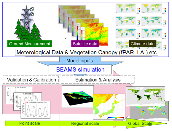
Fig.1 Model Overview
fPAR(Fraction of Photosynthetically Active Radiation), LAI(Leaf Area Index)◆Input/Output model
The BEAMS model (Biosphere model integrating Eco-physiological And Mechanistic approaches using Satellite data, Sasai et al., 2005, 2007) developed by Nagoya University is employed for this calculation. BEAMS was developed to simulate carbon, water and energy processes on the earth surface and their interaction on the basis of ground-based and satellite observational data, and to estimate the amount of exchange and storage.
Spatial data (such as temperature and wind velocity) obtained from ground-based monitoring, satellite observational data (such as precipitation, leaf area index [LAI]), and geographical data (such as vegetation classification, soil classification, soil depth, altitude etc) are used as input data. The estimations of spatial variations of carbon, water and energy fluxes, as well as carbon and water storage in the Far East Asian region from 2001 to 2006 are shown at 1-km grid resolution in monthly time increments.
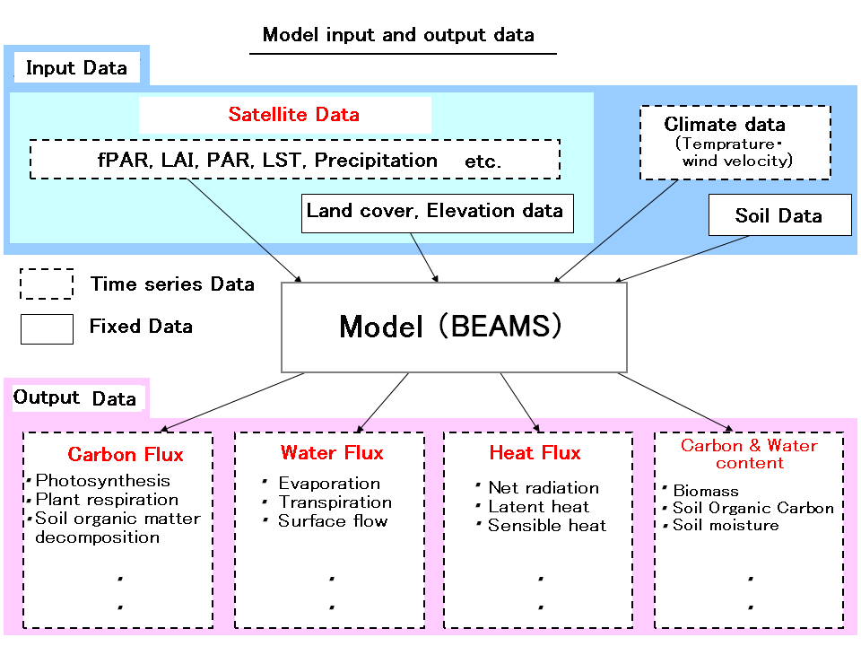
Fig.2 Model input/output
Input data
| Parameter | Dataset Name |
| LST | MOD11A2a, MYD11A2a |
| fPAR,LAI | MOD15A2b, MYD15A2b |
| Albedo | MOD43B3c |
| Air temperature | NCEP/NCARd, WORLDCLIMe |
| Incoming solar radiation | MODIS PAR productf |
| Wind speed | NCEP/NCARd |
| Relative humidity | MODIS VPD productg |
| Precipitation | TRMM/3B43h, WORLDCLIMe |
| Atmospheric CO2 concentration | Observation in Mauna Loai |
| Elevation | SRTM 30j |
| Soil texture | IGBP-DISk |
| Land cover map | MOD12Q1l |
bTerra and Aqua/MODIS Leaf Area Index/FPAR 8-Day L4 Global 1km [Myneni et al.,1997,2002];
cTerra/MODIS Albedo 16-Day L3 Global 1km [Liang et al., 2002; Lucht and Lewis, 2000];
dNational Center for Environmental Prediction and National Center for Atmospheric Research (NCEP/NCAR) re-analysis data set;
eWORLDCLIM data version 1.4 [Hijmans et al., 2005];
fPAR dataset derived from Terra/MODIS reflectance product (MOD02) [Nasahara, 2008];
gVPD dataset derived from the MODIS LST product (MOD11 and MYD11) [Hashimoto et al., 2008];
hTRMM rainfall product 3B43;
iAtmosphericCO2 values (ppmv)derived fromin situ air samples collected atMauna Loa,
Hawaii, USA provided by the CDIACWeb site [Keeling et al., 1995; Keeling et al., 2009];
jShuttle Radar Topography Mission (SRTM) 30 arc-seconds Digital Elevation Model (DEM) dataset [Farr et al., 2007];
kInternational Geosphere-Biosphere Programme (IGBP) - Data and Information System (DIS) soil dataset;
lMODIS Land Cover Type 96-Day L3 Global 1km [Friedl et al., 2010; Strahlar et al., 1999]
◆Model structure
The carbon, water, and energy processes between air-vegetation-soil are simulated, and each process interacts in the BEAMS model.
In the carbon process, photosynthesis, breathing, withering speed of vegetation and the speed of soil organic matter decomposition are calculated (Fig. 3).
In the water and energy processes, evapotranspiration from vegetation and soil, latent heat and the amount of net radiation are calculated (Fig. 4).
The water and heat stress to vegetation is also calculated simultaneously, and it influences the carbon cycle process as a photosynthesis control factor.
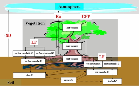
Fig.3 Schematic diagram of carbon cycle process in model
GPP (gross primary production), Ra (autotrophic respiration), LF (litter fall), SD (soil decomposition)
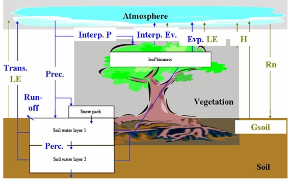
Fig.4 Schematic diagram of the water-energy process in the model
LE (latent heat), Rn (net radiation), H (sensible heat), Inter P. (canopy intercepted precipitation), Inter E. (intercepted evaporation), Evp. (evaporation), Trans. (transpiration), Perc. (percolation) , Gsoil (ground heat flux)
Detais of Model structure
| Model | BEAMS (Biosphere model integrating Eco-physiological And Mechanistic approaches using Satellite data) |
| Phenology | Observation-based remote sensing |
| Carbon pools | Twelve carbon pools are considered; leaf, stem, root biomass, surface (structure, metabolism and microbe), soil (structure, metabolism and microbe), slow, passive, and leached carbon pools. |
| Photosynthesis | Combined Farquhar’s photosynthesis model - Ball-Berry formulation to the LUE concept |
| Allocation | Related to temperature, soil water |
| Autotrophic respiration | Two components (maintenance and growth) |
| Litter fall | Constant mortality and seasonal leaf shedding |
| Soil decomposition | Turnover ratio, which depends on soil water contents and soil temperature |
| Water pools | 4 pools (canopy layer, snow pack, upper and lower soil layer pools) |
| Evaportranspiration | Intercepted, transpiration, and evaporation from two source layers |
| Soil water and run-off | Limited by water holding capacity and wilting point |
| Percolation | Empirical equation based on Darcy’s law |
| Surface radiation budget | Two source layer balance among downward and upward short and long wave radiation on the top of canopy, forest floor and bare ground |
| Energy balance | Balance among net radiation, latent, sensible and ground soil heat fluxes |
◆Model Validation
The estimated results of GPP (gross primary production), NEE (net primary production), LE (latent heat), and Rn (net radiation) by the model were validated with flux measurements at six towers around Japan. Since the differences in seasonal patterns and summer peaks etc at every observation point showed a good consistency, it is feasible to use BEAMS to estimate fluxes in a broad area.
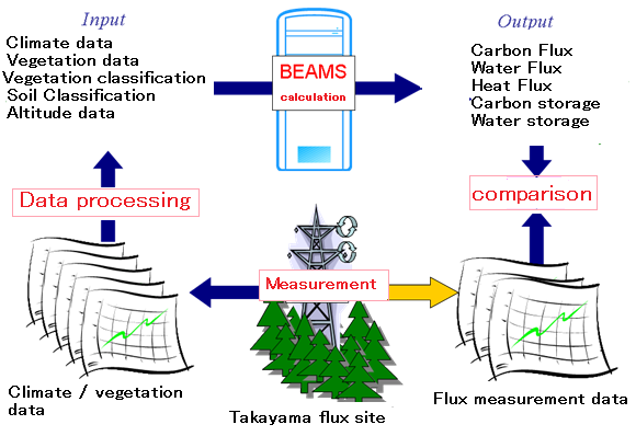
Fig. 5 Overview of the Model Validation Process
Model validation sites
| Site Code | Site Name | PFT | Period |
| TSE | Teshio CC-LaG experiment site | DBFa | 2002 |
| TMK | Tomakomai Flux Research site | DNFb | 2001-2003 |
| LSH | Laoshan site (in China) | DNFb | 2004 |
| TKC | Takayama evergreen coniferous forest | ENFc | 2006-2007 |
| TKY | Takayama deciduous broadleaf forest | DBFa | 2001-2004 |
| SMF | Seto Mixed Forest site | Mixedd | 2005-2007 |
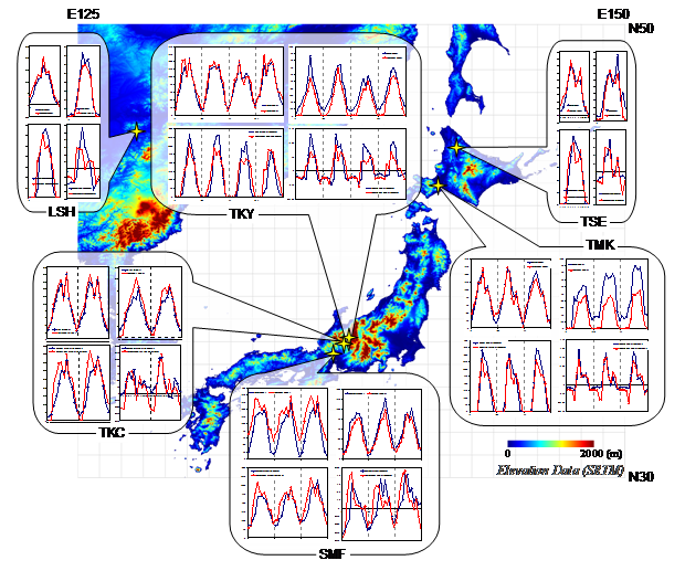
Fig.6 Model validation results

