Metadata
Title
Mammal assemblages recorded by camera traps inside and outside the evacuation zone of the Fukushima Daiichi Nuclear Power Plant accident
Running title
Camera trap data from Fukushima
Name of authors
Fukasawa, Keita12*; Mishima, Yoshio1; Yoshioka, Akira12; Kumada, Nao1; Totsu, Kumiko1; Osawa, Takeshi3
Affiliations
1: Center for Environmental Biology and Ecosystem Studies, National
Institute for Environmental Studies
2: Fukushima Project Office,
National Institute for Environmental Studies
3: National Institute for Agro-Environmental Sciences
*Corresponding author:
TEL: +81.29.850.2676
FAX: +81.50.3730.7037
Email:
ecomoni_fukushima@nies.go.jp,
k.fukasawa37@gmail.com
Abstract
In 2011, the Fukushima Daiichi Power Plant accident resulted in the evacuation of about 81,000 people from the evacuation zone, which suffered from high levels of radioactive contamination. Large-scale and long-term land abandonment can cause changes in species assemblages. Despite the extensive global attention this incident received, open and spatially-explicit datasets of mammal fauna from Fukushima remain quite limited. We established a continuous monitoring protocol using camera traps for mammals both inside and outside the evacuation zone; this paper presents the dataset. These data represent the monitoring results from 45 camera traps from May 2014 to May 2016, including the location and actuation time of each camera, and the list of video records. After the publication of this initial data paper, we intend to continue monitoring until 2023 and the dataset will be hereafter updated with new observations.
Keywords
- forest
- Satoyama
- depopulation
- carnivore
- herbivore
- Japan
Metadata
INTRODUCTION
A serious nuclear accident at the Fukushima Daiichi power plants in 2011 resulted in the evacuation of about 81,000 people from an evacuation zone (i.e. a zone in preparation for the lifting of the evacuation order, a restricted residence area and a difficult-to-return-to zone) (Cabinet Office of Japanese Government 2013). Before the disaster, this area was covered by forest-dominated agricultural landscape. The Satoyama landscape which includes secondary forest and agricultural land has been the majority of land cover, and such landscape has been altered by the land abandonment due to radioactive contamination. Abandonment of agricultural land can affect mammal density in forest (Fujimoto et al. 2015). In some parts of the evacuation area, where radiation levels are high, it will be more than 20 years before inhabitation can resume (Reconstruction Agency 2012). The restoration of ecosystems impacted by this anomalistic, large-scale abandonment will be necessary for social and economic recovery. Scientifically systematic and rigorous monitoring of biodiversity is essential to effectively achieve successful restoration.
Long-term and large-scale land abandonment might alter animal population in the evacuation zone, as well as radiation, on which previous studies at Fukushima and Chernobyl focused (Hiyama et al. 2012; Garnier-Laplace et al. 2013; Hayama et al. 2013; Møller et al. 2013; Akimoto 2014). For example, IAEA(2006) reported on the Chernobyl accident, that wild animals in the evacuation zone are flourishing because of their release from human-induced stresses. Such controversy of negative and positive effects by the nuclear power accident on wildlife is attributed by anecdotal evidences (Møller et al. 2008) due to the lack of systematic long-term monitoring after the accident. The quantitative monitoring by a well-standardized method, such as faunal assemblage estimated with enough number of camera traps, will offer evidence of how animal abundance correlates with the cessation of human activity on a large scale. Impact of land abandonment by human on biodiversity is common worldwide (Queiroz et al. 2014), and a longitudinal monitoring in Fukushima will also address such general ecological issues.
In 2014, we started monitoring faunal assemblages inside and outside of the evacuation zone using infrared camera traps, which present a well-standardized and cost-effective method for monitoring mammal dynamics (Wenguang et al. 2008; O'Connell et al. 2010; Ahumada et al. 2011). It has an advantage to make immediately these data open and available to everyone, because the environmental change following the nuclear plant accident is a both local and global concern. In this data paper, we present the dataset obtained from the monitoring project, which consists of a table showing the durations for which the camera traps were in action and a list of events during which mammals were captured by the camera traps. After the publication of this data paper, it is intended for monitoring to continue until 2023, and the dataset will be hereafter updated with the addition of new observations.
Generally, land use and abandonment are considered crucial factors determining mammal density and diversity (Beckwith 1954; Wenguang et al. 2008) and are undoubtedly relevant to wildlife management strategies. These data can be used to test ecological hypotheses about the effects of land-use change on mammal assemblages on a regional scale and to develop predictive models of conflict, such as damage on forest product and crop, between wild animals and humans using the number of captures per unit time as a population index. Users can download the datasets via the internet under a Creative Commons attribution license CC-BY 4.0 International.
STUDY AREA
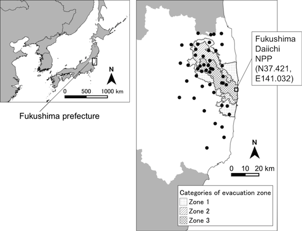
The study area is the eastern part of Fukushima prefecture, located in northeastern Japan, and is enclosed within the following four sets of coordinates: (37.79275°N, 140.55635°E), (37.79275°N, 140.96821°E), (37.03656°N, 140.96821°E), and (37.03656°N, 140.55635°E) (Fig. 1). The study area contains the evacuation zone, which has been categorized since October 2013 into three subzones: a zone in preparation for the lifting of the evacuation order (≤20 mSv/year, Zone 1), a restricted residence area (20-50 mSv/year, Zone 2), and a difficult-to-return-to zone (>50 mSv/year, after 5 years, the air dose rate will still be >20 mSv/year, Zone 3). We set 46 monitoring sites inside and outside the evacuation zone (5 sites in Zone 1, 7 sites in Zone 2, and 13 sites in Zone 3). All the monitoring sites are located in closed forest.
SAMPLING METHODS
A trail camera (Trophycam HD, Bushnell Outdoor Products) is installed at each monitoring site during May to August 2014. Cameras were adjusted to video mode, recording for 30 seconds with 10-second or more trigger interval. The image resolution was 1280×720 pixels (720p) and the frame rate was 30 fps in daytime mode (visible light imaging) and 18 fps in night-vision mode (infrared monochrome imaging). Cameras were fixed to tree trunks at a height of about 1 m. Data collection and battery exchange have been conducted biannually. In 2014, the data collection and battery exchange were conducted in October and partially in July. Mammals that appeared in the videos were identified and recorded to the event list. The duration between battery exchanges was defined as the “occasion”, and the start and end times of each occasion for each camera were recorded. The occasion values provide information on the durations for which the camera traps were active, and make it possible to calculate records per unit time. An occasion end time was defined as the time when the last video file was recorded, if a camera was inactive due to battery exhaustion or mechanical failure at the visit.
The sensor cameras used in this study are essentially suitable tools for monitoring medium to large sized mammals (O'Brien et al. 2011). The capture efficiency of small mammals (e.g. rodents and shrews), can be highly sensitive to small variations in the installation of cameras, and we do not recommend treating the data on small mammals belonging to the orders Rodentia, Soricomorpha and Chiroptera as correlative indices of abundance.
CONTRIBUTORS
A. Dataset owner and contact person
Name: NIES Fukushima Terrestrial Ecosystem Monitoring Team
Affiliation: Fukushima Project Office / Center for
Environmental Biology and Ecosystem Studies, National Institute for
Environmental Studies
Address: 16-2 Onogawa, Tsukuba, Ibaraki, 305-8506 Japan
Mail: ecomoni_fukushima@nies.go.jp
B. Data management
Name: Keita Fukasawa
Affiliation: Fukushima Project Office / Center for
Environmental Biology and Ecosystem Studies, National Institute for
Environmental Studies
TAXONOMY AND SYSTEMATICS
All species were identified by the authors or by research collaborators who are mammal experts. If we could not obtain sufficient information for species identification from a video image, we recorded a higher taxonomic level (e.g. order and class) which could be certainly specified. Scientific names followed Ohdachi et al. (Ohdachi et al. 2009) and the Catalogue of Life (http://www.catalogueoflife.org/).
DATA FORMAT
The published data were provided in two types: (1) a full dataset of occurrence and survey effort data, and (2) occurrence data formatted according to the Darwin Core Archives (Darwin Core Task Group (TDWG) 2009).
The full dataset was formatted into two distinct tables, (1) the event table recording information on each video (monitoring site ID, date, type of animal recorded and the number of individuals) and (2) the occasion table recording monitoring site ID, geographical coordinate, start date and end date.
The Darwin Core Archives, a data format for recording the occurrence of organisms worldwide (e.g., specimen records and observational records), is the de facto standard for describing species occurrences (Osawa et al. 2011). It has been used in the Ecological Research Data Paper Archives (Osawa 2013; Voraphab et al. 2015).
All tables are provided as tab delimited text files with UTF-8 encoding.
DATA FILE COMPONENTS
| Data file name | Inside files | Description |
|---|---|---|
| NIES_FTEM_cameratrap_detection.txt | - | Records of camera trap detections including the monitoring site ID, date, time, identity of animal detected and number of individuals. |
| NIES_FTEM_cameratrap_occasion.txt | - | Records of camera trapping occasions including the monitoring site ID, geographical coordinate, start date and end date. |
| NIES_FTEM_cameratrap_evacuation.txt | - | Evacuation zone category of each monitoring site and its designation date. |
| dwca_NIES_FTEM_cameratrap.zip | eml.xml | Simplified ecological metadata language files according to TDWG role. |
| meta.xml | Metafile that defines the contents of Darwin Core. | |
| NIES_FTEM_cameratrap_DwC.txt | Darwin Core formatted records of camera trap detections including date, time, identity of animal detected, number of individuals and geographical coordinate. |
DATA TABLE DESCRIPTIONS
A. NIES_FTEM_cameratrap_detection.txt
| Contents name | Description |
|---|---|
| institutionCode | The code (or acronym) identifying the institution administering the collection in which the organism record is cataloged. |
| collectionCode | The code (or acronym) identifying the collection. |
| pictID | The serial number of event. |
| locationID | The code identifying the research point. |
| occasionID | The code identifying the occasion. |
| Modified | The date last modified. |
| Y | The year recorded. |
| M | The month recorded. |
| D | The date recorded. |
| Hm | The time recorded. |
| Object | Japanese name of recorded animals, organized alphabetically. |
| Class | The scientific name of class. |
| Genus | The scientific name of genus. |
| Species | The scientific name of species. |
| individualCount | The number of recorded animals. |
| identify.vague | The indicator variable meaning whether the animal was identified at species level (0), or not (1). |
B. NIES_FTEM_cameratrap_occasion.txt
| Contents name | Description |
|---|---|
| institutionCode | The code (or acronym) identifying the institution administering the collection in which the organism record is cataloged. |
| collectionCode | The code (or acronym) identifying the collection. |
| locationID | The code identifying the research point. |
| occasionID | The code identifying the occasion. |
| cameraModel | The model and lot number of the sensor camera. |
| Modified | The date last modified. |
| decimalLatitude | The decimal degrees of latitude. |
| decimalLongitude | The decimal degree of longitude. |
| startDate | The start date of occasion. |
| startTime | The start time of occasion. |
| endDate | The end date of occasion. |
| endTime | The end time of occasion. |
| Abort | The indicator variable meaning whether a camera had been out of action until the following data collection (0), or not (1). |
C. NIES_FTEM_cameratrap_evacuation.txt
| Contents name | Description |
|---|---|
| locationID | The code identifying the research point. |
| evacuationCategory | The category of evacuation zone: 0 = Non-evacuation zone, 1 = Zone in preparation for the lifting of the evacuation order (Zone 1), 2 = Restricted residence area (Zone 2), 3 = Difficult-to-return-to zone (Zone 3). |
| designatedDate | The date when a site is designated as the category shown in the column “evacuationCategory”. For sites which have never been designated as evacuation zone, NAs were assigned. |
DATA STATUS
Latest Update : Oct 20 2016.
These data span the period May 2014 – May 2016. This census is continuing after May 2016 but these data have not yet been compiled. The published dataset will be updated after compilation.
ACCESSIBILITY
License and Usage Rights
Users can download the datasets via the internet under a Creative Commons attribution license CC-BY 4.0 International (https://creativecommons.org/licenses/by/4.0/legalcode).
SUPPLEMENTARY INFORMATION
The R (R Core Team 2014) function for tabulating number of events and duration of camera in action by arbitrary intervals is available at Github (https://github.com/ecomoni-fukushima/Conversion-tools-for-camera-trapping-data-in-R ).
ACKNOWLEDGEMENTS
This study was conducted with the help of the Kanto Regional Forest Office, Iwaki District Forest Office, Fukushima District Forest Office, Fukushima Prefecture and local governments including Iitate village, Namie town and Souma city. We are grateful to Dr. Masaki Tamaoki, Dr. Hiroyuki Oguma and Dr. Noe Matsushima for helping with field work, and Naoko Goto for helping with the identification of species. We thank two anonymous reviewers for providing valuable comments on the manuscript. This work was financially supported by the research program on Disaster Environment, an internal budget of the National Institute for Environmental Studies. The internal budget was originally issued by the Ministry of Environment, Japan. (http://www.nies.go.jp/shinsai/index-e.html).
LITERATURE CITED
Ahumada JA, Silva CEF, Gajapersad K, Hallam C, Hurtado J, Martin E, McWilliam A, Mugerwa B, O'Brien T, Rovero F, Sheil D, Spironello WR, Winarni N, Andelman SJ (2011) Community structure and diversity of tropical forest mammals: data from a global camera trap network. Philos Trans R Soc Lond, Ser B: Biol Sci 366: 2703-2711. DOI: 10.1098/rstb.2011.0115
Akimoto S (2014) Morphological abnormalities in gall-forming aphids in a radiation-contaminated area near Fukushima Daiichi: selective impact of fallout? Ecol Evol 4: 355-369. DOI: 10.1002/ece3.949
Beckwith SL (1954) Ecological Succession on Abandoned Farm Lands and Its Relationship to Wildlife Management. Ecol Monogr 24: 349-376. DOI: 10.2307/1943236
Cabinet Office of Japanese Government (2013) About revision of the evacuation zone. URL: http://www.meti.go.jp/earthquake/nuclear/pdf/131009/131009_02a.pdf (latest access: 14 April 2015) (in Japanese)
Darwin Core Task Group (TDWG) (2009) Darwin Core. URL: http://rs.tdwg.org/dwc/ (latest access: Sep. 24 2015)
Fujimoto R, Mitsunaga T, Takeuchi M (2015) Influence of evacuation orders on the occurrence of the wild boar Sus scrofa in farmlands in the northern evacuation zone of the accident at Tokyo Electric Power Company's Fukushima Daiichi Nuclear Power Station. Mammalian Science 55: 145-154. DOI: 10.11238/mammalianscience.55.145 (in Japanese with English summary)
Garnier-Laplace J, Geras’kin S, Della-Vedova C, Beaugelin-Seiller K, Hinton TG, Real A, Oudalova A (2013) Are radiosensitivity data derived from natural field conditions consistent with data from controlled exposures? A case study of Chernobyl wildlife chronically exposed to low dose rates. J Environ Radioact 121: 12-21. DOI: http://dx.doi.org/10.1016/j.jenvrad.2012.01.013
Hayama S, Nakiri S, Nakanishi S, Ishii N, Uno T, Kato T, Konno F, Kawamoto Y, Tsuchida S, Ochiai K, Omi T (2013) Concentration of Radiocesium in the Wild Japanese Monkey (Macaca fuscata) over the First 15 Months after the Fukushima Daiichi Nuclear Disaster. PLoS ONE 8: e68530. DOI: 10.1371/journal.pone.0068530
Hiyama A, Nohara C, Kinjo S, Taira W, Gima S, Tanahara A, Otaki JM (2012) The biological impacts of the Fukushima nuclear accident on the pale grass blue butterfly. Sci Rep 2. DOI: 10.1038/srep00570
International Atomic Energy Agency (2006) Environmental consequences of the Chernobyl accident and their remediation: twenty years of experience. Vienna
Møller AP, Mousseau TA, de Lope F, Saino N (2008) Anecdotes and empirical research in Chernobyl. Biol Lett 4: 65-66. DOI: 10.1098/rsbl.2007.0528
Møller AP, Nishiumi I, Suzuki H, Ueda K, Mousseau TA (2013) Differences in effects of radiation on abundance of animals in Fukushima and Chernobyl. Ecol Indicators 24: 75-81. DOI: http://dx.doi.org/10.1016/j.ecolind.2012.06.001
O'Brien T, Kinnaird MF, Wibisono HT (2011) Estimation of species richness of large vertebrates using camera traps: an example from an Indonesian rainforest. In: AF O'Connell, JD Nichols, KU Karanth (eds) Camera traps in animal ecology: methods and analyses. Springer, pp. 233-252
O'Connell AF, Nichols JD, Karanth KU (2010) Camera traps in animal ecology: methods and analyses. Springer
Ohdachi SD, Ishibashi Y, Iwasa MA, Saito T (2009) The wild mammals of Japan. Shoukadoh Book Sellers, Kyoto
Osawa T (2013) Monitoring records of plant species in the Hakone region of Fuji-Hakone-Izu National Park, Japan, 2001–2010. Ecol Res 28: 541-541. DOI: 10.1007/s11284-013-1049-6
Osawa T, Kurihara T, Nakatani Y, Yoshimatsu S (2011) Improvement of biodiversity information and utilization: a case study in developing an insectarium browsing system based on Internet technology. Japanese Journal of Conservation Ecology 16: 231-241. (in Japanese with English summary)
Queiroz C, Beilin R, Folke C, Lindborg R (2014) Farmland abandonment: threat or opportunity for biodiversity conservation? A global review. Front Ecol Environ 12: 288-296. DOI: 10.1890/120348
R Core Team (2014) R: A language and environment for statistical computing. R Foundation for Statistical Computing, Vienna, Austria. URL: http://www.R-project.org/ (latest access: Aug. 13 2015)
Reconstruction Agency (2012) Prediction of air radiation dose rate. URL: http://www.reconstruction.go.jp/topics/shiryo3.pdf (latest access: Jul. 14 2015) (in Japanese)
Voraphab I, Hanboonsong Y, Kobori Y, Ikeda H, Osawa T (2015) Insect species recorded in sugarcane fields of Khon Kaen Province, Thailand, over three seasons in 2012. Ecol Res 30: 415-415. DOI: 10.1007/s11284-015-1252-8
Wenguang Z, Yuanman H, Jinchu H, Yu C, Jing Z, Miao L (2008) Impacts of land-use change on mammal diversity in the upper reaches of Minjiang River, China: Implications for biodiversity conservation planning. Landscape Urban Plann 85: 195-204. DOI: http://dx.doi.org/10.1016/j.landurbplan.2007.11.006
