

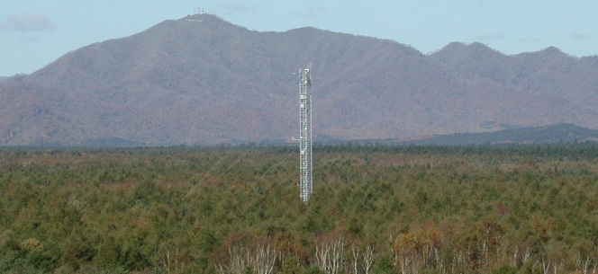
Tomakomai site before 2004
Overview
The monitoring had been conducted in cooperation with the Experimental Plantation and Faculty of Agriculture of Hokkaido University, and Environmental Sciences Research Center of Hokkaido along with other institutions. In addition, comprehensive field research on the carbon cycle in forest ecosystem was conducted with the cooperation of the National Institute of Advanced Industrial Science and Technology and Faculty of Agriculture of Osaka Prefecture University. Unfortunately, the tower and observation system were destroyed by the strong winds during a typhoon in 2004 and the monitoring was stopped . The following is an overview of the observations conducted from July 2000 to September 2004.
Observation site
| Location |
Forest No.1196-1198, Tomakomai National Forest, Tomakomai, Hokkaido (Within the jurisdiction of Tomakomai Office, Iburi-higashi Forest Management Office) Latitude and Longitude: 42º 44' 13.1" N,141º 31' 7.1" E Elevation: 115-140 m |
|---|---|
| Land |
Gradient: 1-2 degrees Soil type: Volcanogenous regosol |
| Vegetation |
Type: Japanese larch forest Tree age: about 45 years old Tree height: 18~20 m Area: 117 ha (Larix forest 98 ha) Dominant Species (Over story): Japanese larch (Larix Kaempferi Sarg.), Birch (Betula ermanii and Betula platyphylla), Japanese elm (Ulmus japonica), Spruce (Picea jezoensis) Dominant Species (Understory): Fern (Dryopteris crassirhizoma, Dryopteris austriaca) and Pachysandra terminalis |
| Mean annual air temperature | 6.5℃ (2001-2003) |
| Annual precipitation | 1055 mm (2001-2003) |
| Annual global solar radiation | 4199 MJm-2 (2001-2003) |
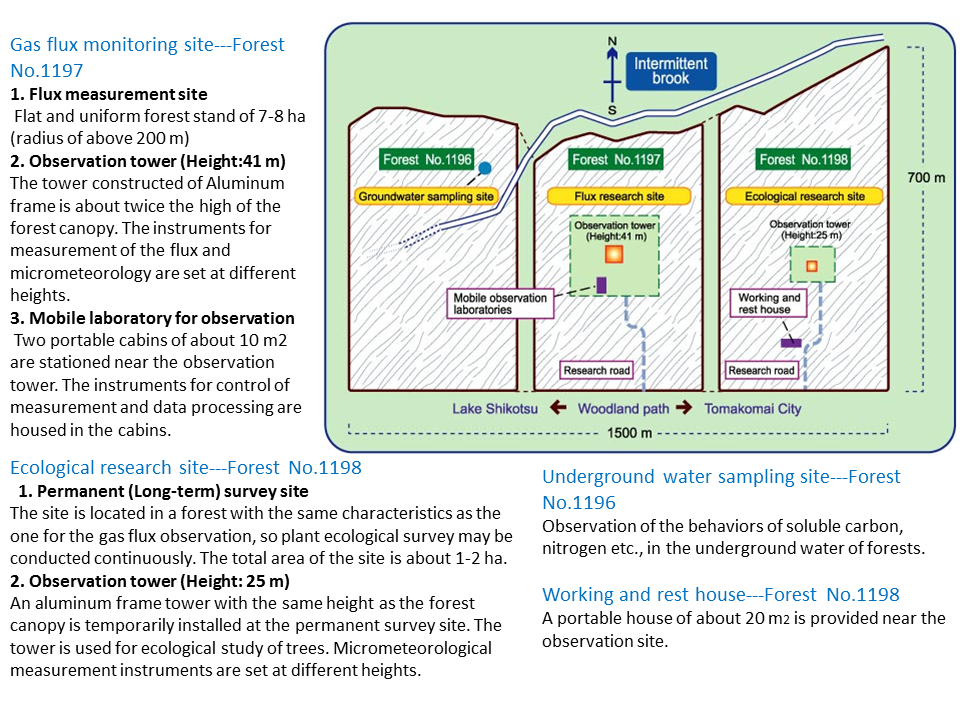
Observation Facilities (detail)
| Observation tower (2) |
Gas flux monitoring site: Height 41 m (Aluminium frame) Ecological research site: Height 25 m (Alminium frame) |
|---|---|
| Mobile laboratory (2) | Two portable cabins of about 10 m2 |
Observation System
| System | Item | Number | Installed places |
|---|---|---|---|
| Eddy covariance method | Three-dimensional sonic anemometer-thermometer | 2 | Tower boom, tower |
| Open-path systems (CO2 flux, latent heat flux) | 3 | Tower boom (2), tower | |
| Closed-path systems (CO2 flux, latent heat flux) | 2 | Tower boom, tower | |
| Concentrations | CO2 profile | 1 set | 10 elevation |
| Soil respiration | Continuous (automated chambers) | Forest floor | |
| Phenology | Fisheye Lens Camera | 2 | Tower, Forest floor |
| Meteorology | Solar radiation | 10 | Tower top, Tower (3), Forest floor (6) |
| Photosynthetic active radiation (PPFD) | 5 | tower (2), Forest floor (3) | |
| 1 set | In pairs: Tower top | ||
| UV-A radiation | 1 | Tower top | |
| UV-B radiation | 1 | Tower top | |
| Direct/sky solar radiation | 1 | Tower top | |
| Spectral radiation (Rotary type) | 2 | In pairs: Tower top, Forest floor | |
| Net radiation | 3 | Tower boom, Tower, Forest floor | |
| Air temperature, Air humidity | 8 | Tower boom, Tower (6), Forest floor | |
| Two-dimensional Wind direction and speed | 7 | Tower (6), Forest floor | |
| Atmospheric pressure | 2 | Ground level, Forest floor | |
| Precipitation | 4 | Tower top, Forest floor | |
| Snow depth | 1 | Ground level | |
| Soil temperatur | 12 | Forest floor (mesuring at 3 points in 4 different depths) | |
| Soil water content | 6 | Forest floor (measuring at 3 points in 2 different depths) | |
| Soil heat flux | 5 | Forest floor (measuring at 5 points) |
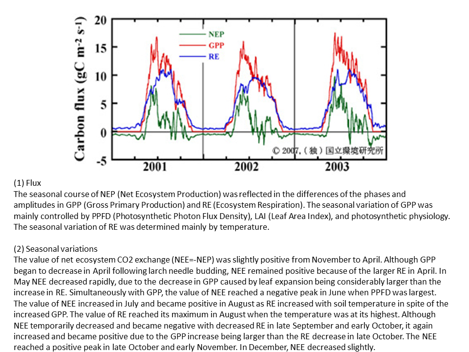
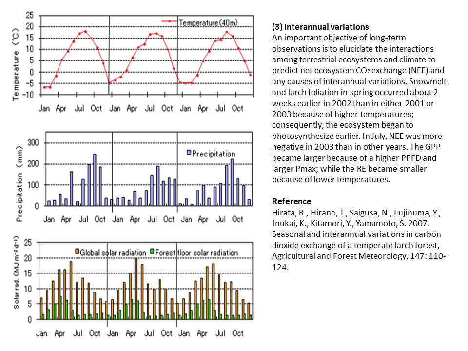
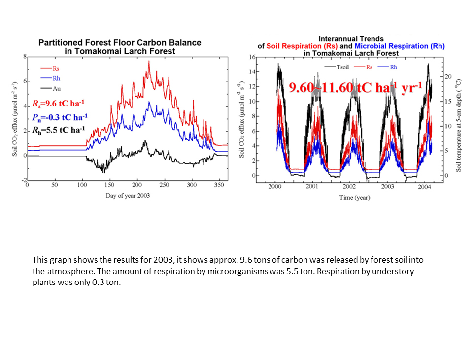
Results
- Available Observation Data (Go to Database Portal)
- Some results (Click on the image to see details)