熱帯林・樹木のデータベース
このデータベースはNIES-FRIM-UPM熱帯林多様性プロジェクトによって構築されたもので、マレーシア、タイ、スリランカなどの調査地で蓄積された熱帯林の樹木に関する貴重な資料です。
下記の各項目をクリックすると、データベースのサンプルをご覧いただけます。
樹木:種のリスト
毎木データ
- マレーシア、パソ天然林50ha(85年、90年、95年、00年、05年)の毎木直径データおよびマッピングデータの例
- タイ ホイカーケン50ha(00年)の毎木直径データおよびマッピングデータの例
- スリランカ シンハラジャ25ha(00年)の毎木直径データおよびマッピングデータの例
毎種データ
熱帯林に生息する樹木の種名、科名リストの例
| no | code | name | family | class |
|---|---|---|---|---|
| 1 | ACROPO | ACRONYCHIA PORTERI | family | C |
| 2 | ACTIM1 | ACTINODAPHNE MACROPHYLLA | LAURACEAE | U |
| 3 | ACTIPR | ACTINODAPHNE PRUINOSA | LAURACEAE | U |
| 4 | ACTISE | ACTINODAPHNE SESQUIPEDALIS | LAURACEAE | U |
| 5 | ADENBI | ADENANTHERA BICOLOR | LEGUMINOSAE | C |
| 6 | AGLAAS | AGLAIA ASPERA | MELIACEAE | U |
| 7 | AGLACO | AGLAIA CORDATA | MELIACEAE | U |
| 8 | AGLAE1 | AGLAIA EXSTIPULATA | MELIACEAE | C |
| 9 | AGLAFO | AGLAIA FORBESII | MELIACEAE | C |
| 10 | AGLAGA | AGLAIA GANGGO | MELIACEAE | C |
| 11 | AGLAGL | AGLAIA GLABRIFLORA | MELIACEAE | C |
| 12 | AGLAGR | AGLAIA GRANDIS | MELIACEAE | U |
| 13 | AGLAME | AGLAIA MELIOSMOIDES | MELIACEAE | U |
| 14 | AGLAO2 | AGLAIA OLIGOCARPA | MELIACEAE | U |
| 15 | AGLAOD | AGLAIA ODORATISSIMA | MELIACEAE | U |
| 16 | AGLAOL | AGLAIA OLIGOPHYLLA | MELIACEAE | C |
| 17 | AGLAPA | AGLAIA PALEMBANICA | MELIACEAE | U |
| 18 | AGLARB | AGLAIA RUBESCENS | MELIACEAE | C |
| 19 | AGLARI | AGLAIA RIDLEYI | MELIACEAE | C |
| 20 | AGLARU | AGLAIA RUFA | MELIACEAE | U |
マレーシア、パソ天然林50ha(85年、90年、95年、00年、05年)の毎木直径データおよびマッピングデータの例
| label | x | y | d_85 | d_90 | d_95 | d_00 | d_05 | pname | class |
|---|---|---|---|---|---|---|---|---|---|
| 6 | 0.7 | 1.6 | 16 | 19.4 | 19.7 | 20.4 | 22.4 | EUGEDU | C |
| 69 | 5.1 | 15.1 | 84.5 | 82 | 83.6 | 85 | 86 | DIPTCR | E |
| 82 | 8.7 | 18.9 | 10.4 | 11.6 | 11.9 | D | D | GIRONE | U |
| 90 | 9.1 | 17.6 | 11.2 | 12.5 | 13.4 | 13.9 | 14.6 | EUGECL | C |
| 101 | 5.8 | 12.5 | 46.1 | 46.2 | 47.3 | 48 | D | SHORM1 | E |
| 104 | 7.2 | 14 | 8.2 | 9.5 | 10.3 | 11.4 | 12.3 | ANT1CO | U |
| 116 | 5.2 | 5.9 | 15.1 | 16.1 | 18.8 | 22.3 | 26.4 | MONOMA | C |
| 119 | 5.7 | 9.6 | 9.8 | 12.1 | 14.2 | D | 21.7 | SHORP1 | E |
| 124 | 7.3 | 9.9 | 26 | 27 | 28.2 | 29.2 | 30.7 | XANTRU | C |
| 140 | 8.8 | 0.6 | 5 | 10.4 | 18.1 | D | D | QUERAR | E |
| 165 | 10.8 | 7.5 | 89 | 89 | 89.2 | D | D | SHORL1 | E |
| 176 | 13.1 | 14.8 | 11 | 12.6 | 13.5 | 15.1 | 17.3 | AIDIWA | U |
| 194 | 14.1 | 18.4 | 67.5 | 69.2 | 69.5 | D | D | SHORL2 | E |
| 197 | 11.5 | 17.1 | 17.6 | 18.5 | 20.3 | 23 | 25.6 | NEOBHE | E |
| 198 | 13.7 | 17.4 | 6.4 | 9.1 | 11.6 | 13.8 | 14.9 | ARCHBU | U |
| 221 | 17.9 | 17.5 | 13.7 | 17.3 | 22.9 | 28.8 | 34.7 | QUERAR | E |
| 228 | 17 | 16.6 | 33.8 | 36.4 | 37.3 | 37.5 | 36.7 | SHORAC | E |
| 241 | 19.1 | 12.4 | 9.7 | 12.3 | 14.4 | 15.2 | 17.3 | GARCNE | U |
| 256 | 19 | 8.9 | 5 | 9.9 | 17.8 | D | D | LITHEW | C |
| 264 | 17.1 | 5.4 | 8 | 10.4 | 12.7 | 13.4 | 15.4 | CANALL | C |
| label | :Label tag for every tree (Tree no) |
|---|---|
| x | :Cordinate-x displays the horizontal distance (m) from origin 0 as the southwest point of the plot. |
| y | :Cordinate-y displays the vertical distance (m) from origin 0 as the southwest point of the plot. |
| d_85 | :Tree diameter at breast height (DBH/cm) measured in year 1985 |
| d_90 | :Tree diameter at breast height (DBH/cm) measured in year 1990 |
| d_95 | :Tree diameter at breast height (DBH/cm) measured in year 1995 |
| d_00 | :Tree diameter at breast height (DBH/cm) measured in year 2000 / D:death |
| d05 | :Tree diameter at breast height (DBH/cm) measured in year 2005 / D:death |
| pname | :Species code (in 6 letters) |
| class | :Classification of tree (E:Emergent ; C:Canopy ; U:Understory ; T:Treelet ; S:Shrub) |
タイ、ホイカーケン50ha(00年)の毎木直径データおよびマッピングデータの例
| no | code | x | y | 92DBH | 2000DBH | class |
|---|---|---|---|---|---|---|
| 1 | DIMOLO | 9 | 2.7 | 27.37 | 31.95 | M |
| 2 | CROTOB | 6.3 | 1.2 | 2 | . | M |
| 3 | CROTOB | 6.3 | 1.3 | 1.45 | . | M |
| 4 | VATICI | 12.5 | 2.5 | 53.72 | 57.07 | M |
| 5 | DIMOLO | 10.6 | 10 | 33.95 | 36.6 | M |
| 6 | POLYVI | 0.3 | 10.8 | 21.87 | 24.67 | M |
| 7 | POLYVI | 0.4 | 12.6 | 12.4 | . | M |
| 8 | CASSTI | 8 | 14.1 | 1.01 | . | M |
| 9 | CASSTI | 7.8 | 14 | 1.75 | . | M |
| 10 | CASSTI | 7.9 | 13.8 | 1.75 | . | M |
| 11 | CASSTI | 7.9 | 13.8 | 1.26 | . | B |
| 12 | CASSTI | 7.9 | 13.8 | 1.25 | . | B |
| 13 | CROTOB | 13.1 | 11.3 | 4.15 | . | M |
| 14 | CROTOB | 14.3 | 10.3 | 2.09 | 5.09 | M |
| 15 | CROTOB | 15.6 | 10.6 | 1.98 | . | M |
| 16 | RADEIG | 17.1 | 10.5 | 16.1 | 18.02 | M |
| 17 | MARKST | 17.5 | 9.5 | 4.55 | 7.12 | M |
| 18 | CASSFI | 18.7 | 9 | 1.04 | . | M |
| 19 | CROTOB | 19.5 | 12.3 | 18.7 | 18.83 | M |
| 20 | MURRPA | 17 | 12.3 | 15.5 | 16.58 | M |
| no | :Label tag for every tree (Tree No) |
|---|---|
| code | :Species code (in 6 letters) |
| x | :Cordinate-x displays the horizontal distance (m) from origin 0 as the southwest point of the plot |
| y | :Cordinate-y displays the vertical distance (m) from origin 0 as the southwest point of the plot |
| 92DBH | :Tree diameter at breast height (DBH/cm) measured in year 1992 |
| 2000DBH | :Tree diameter at breast height (DBH/cm) measured in year 2000 |
| class | : Classification of tree (M:? ; B:?) |
スリランカ シンハラジャ25ha(00年)の毎木直径データおよびマッピングデータの例
| QUAD_X | QUAD_Y | SUBQUAD_X | SUBQUAD_Y | TREENO | GLOBAL_X | GLOBAL_Y | SP_CODE | DBH2000 |
|---|---|---|---|---|---|---|---|---|
| 1 | 14 | 3 | 1 | 14241 | 35.82 | 286.5 | ABARBI | 11 |
| 1 | 12 | 2 | 3 | 13839 | 33.39 | 258.12 | ABARBI | 2.4 |
| 1 | 12 | 2 | 2 | 13777 | 33.42 | 250.55 | ABARBI | 1.65 |
| 1 | 13 | 1 | 0 | 13917 | 29.41 | 261.19 | ABARBI | 7.75 |
| 1 | 14 | 3 | 1 | 14239 | 36.82 | 286 | ABARBI | 11.2 |
| 1 | 12 | 3 | 3 | 13805 | 39.48 | 256.44 | ABARBI | 11.25 |
| 1 | 14 | 1 | 1 | 14267 | 28.67 | 288.17 | ABARBI | 1.1 |
| 1 | 14 | 1 | 1 | 14268 | 29.04 | 286.92 | ABARBI | 1.1 |
| 1 | 14 | 3 | 3 | 14335 | 38.43 | 298.01 | ABARBI | 5.25 |
| 1 | 18 | 1 | 1 | 15376 | 28.3 | 366.73 | ABARBI | 1.2 |
| 2 | 13 | 3 | 1 | 23968 | 56.72 | 266.42 | ABARBI | 2.25 |
| 2 | 12 | 2 | 1 | 23669 | 52.65 | 245.82 | ABARBI | 18.2 |
| 2 | 12 | 3 | 1 | 23660 | 56.25 | 248.37 | ABARBI | 1.9 |
| 2 | 12 | 1 | 1 | 23678 | 49.04 | 247.23 | ABARBI | 18.45 |
| 2 | 12 | 3 | 0 | 23641 | 59.58 | 240.8 | ABARBI | 3.9 |
| 2 | 13 | 2 | 1 | 24010 | 52.67 | 265.47 | ABARBI | 9.5 |
| 2 | 12 | 2 | 2 | 23770 | 52.6 | 253.27 | ABARBI | 19.75 |
| 2 | 12 | 2 | 2 | 23760 | 52.25 | 250.1 | ABARBI | 12.45 |
| 2 | 12 | 3 | 3 | 23812 | 56.95 | 256.49 | ABARBI | 1.3 |
| 2 | 14 | 3 | 1 | 24209 | 55.61 | 285.51 | ABARBI | 46.5 |
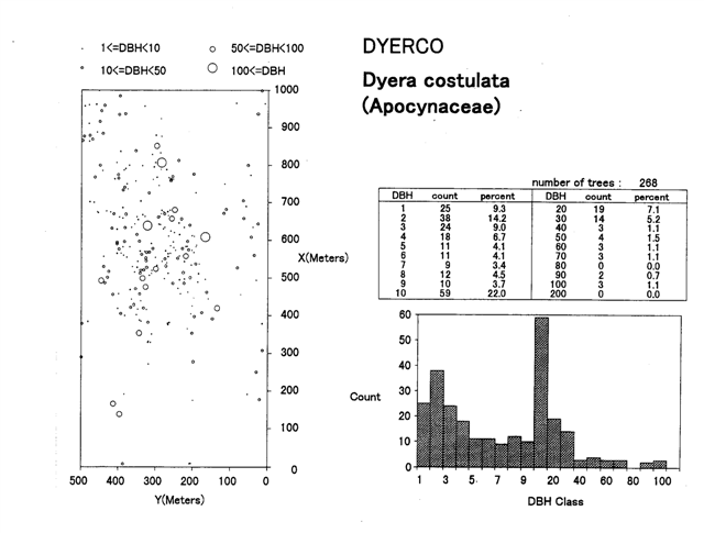
マレーシア パソ天然林50ha(95年)の種毎のマップおよび個体数データの例
Malaysia Pasoh forest 50-ha plot
Distribution map for Dyera constulata (left) / Number of trees by DBH class (right)
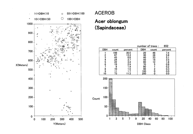
タイ ホイカーケン50ha(00年)の種毎のマップおよび個体数データの例
Huai Kha Khaeng Wildlife Sanctuary, Western Thailand
Distribution map for Acer oblongum (left) / Number of trees by DBH class (right)
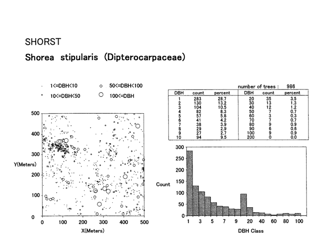
スリランカ シンハラジャ25ha(00年)の種毎のマップおよび個体数データの例
Sinharaja Forest Reserve, Sri Lanka
Distribution map for Shorea stipularis (left) / Number of trees by DBH class (right)