
Fujihokuroku site
Overview
The Center for Global Environmental Research (CGER) established the Tomakomai Flux Research Site in 1999 to carry out integrated monitoring on the carbon balance in forest ecosystems. However, the site was damaged by the strong winds accompanying a typhoon in 2004. For this reason we established the Fuji Hokuroku Flux Observation Site in the foothills of Mt. Fuji as an alternative base for monitoring, and began observations in January 2006. At this observation site, we apply various methodologies to estimate the carbon sequestration in forest ecosystems, such as the eddy covariance method, forest vegetation and soil function (photosynthesis, respiration) observations, tree growth and litter amount measurements, and remote sensing method . Recently, we also began measurements of methane and BVOC gases - which may directly or indirectly affect global warming - adopting a new measurement system. This integrated monitoring should be beneficial for further assessment and understanding of the exchanges of gas, heat, water and small particles between the land and atmosphere.
Observation site
| Location | Aza Kawahara, Kamiyoshida, Fujiyoshida City, Yamanashi Pref. Latitude and Longitude: 35º 26' 36.7"N, 138º 45' 53.0"E Elevation: 1050-1150 m |
|---|---|
| Land | Gradient: 3-4 degrees Soil type:Coarse-grain volcanic ash |
| Vegetation |
Dominant species: Planted larches Tree planted in: 1950 Tree hight: 20-25 m Area: 150 ha Spontaneous vegetation: Fujizakura (Prunus incisa) Forest floor: Broad leaved plants |
| Mean annual air temperature | 8.8℃ (average of 2006-2010) |
| Annual precipitation | 1716 mm (average of 2006-2010) |
Observation Facilities
| Monitoring tower (Tower Instrument Map) |
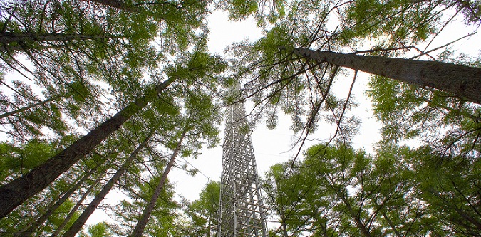
Height: 32 m (aluminum) CO2/H2O, micrometeorology, and remote sensing monitoring systems are set on a boom installed on the top of the tower. |
|---|---|
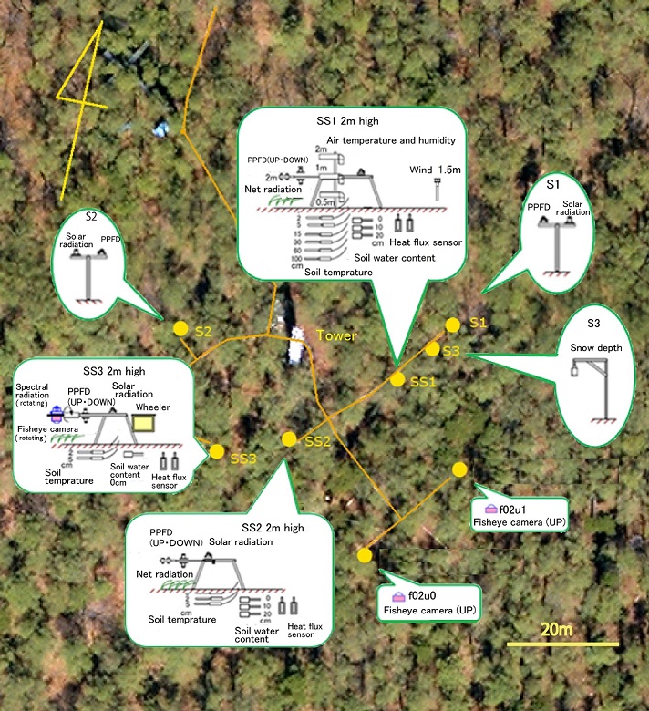
| Micrometeorology instruments (8 sets) (Forest Floor Map) |
Instruments are located on the forest floor to monitor micrometeorological phenomena and soil. |
| Photosynthesis, Respiration monitoring system | Chamber systems is installed to monitor CO2 balance of larch tree and soil. |
| Monitoring office | Portable cabin (10㎡) for data control systems. |
Observation System
| System | Item | Number | Height (m) |
|---|---|---|---|
| Eddy covariance method | Three-dimensional sonic anemometer-thermomete | 1 | 35 |
| Open-path systems (CO2 and H2O flux) | 1 | 35 | |
| Closed-path systems (CO2 and H2O flux) | 1 | 35 | |
| Enclosed-path systems (CO2 flux, latent heat flux) | 1 | 35 | |
| Concentration | CO2 profile | 10 | 35, 32, 27, 22, 16, 10, 4.5, 2, 1, 0.5 |
| Soil respiration | Continuous (automated chambers) | 24 | Forest floor |
| Phenology | Fisheye lens camera | 6 | 32, 22, 2(2), 2(rotate) |
| Digital Camera | 4 | 26(N), 24(E, N), 23(W) | |
| Meteorology | Global solar radiation (incoming) | 6 | 32, 2(5) |
| Global solar radiation (outgoing) | 3 | 30, 2(2) | |
| Net radiation | 3 | 32, 2(2) | |
| PPFD (incoming) | 6 | 32, 2(5) | |
| PPFD (outgoing) | 4 | 30, 2 (3) | |
| Direct/diffuse spectral radiation | 1 | 32 | |
| Spectral radiation (incoming) | 2 | 32, 2(rotate) | |
| Spectral radiation (outgoing) | 2 | 30, 2(rotate) | |
| Spectral direct solar radiation | 1 | 32 | |
| Air temperature and humidity | 10 | 35, 32, 27, 22, 16, 10, 4.5, 2, 1, 0.5 | |
| Two-dimensional wind direction and speed | 7 | 32, 27 ,22, 16, 10, 4.5, 2 | |
| Atmospheric pressure | 1 | 2 | |
| Precipitation | 1 | 32 | |
| Snow depth | 1 | 2 | |
| Soil temperature | 13 | 0(3), 0.02(3), 0.05(3), 0.15, 0.3, 0.6, 1 | |
| Soil water content | 7 | 0(3), 0.1(2), 0.2(2) | |
| Soil heat flux | 3 | 0.02 |
Cooperation with other organizations
| Topic | Method |
|---|---|
| Methane flux observation | Relaxed eddy covariance method and laser spectrometer |
| Observation of soil methane flux | Automated chamber and laser spectrometer |
| BVOC flux observation | Relaxed eddy covariance method laboratory experiments |
| Sampling aerosol | High Volume Sampler |
Results
- Available Observation Data (Go to Database Portal)
- Some results (Click on the image to see details)
-
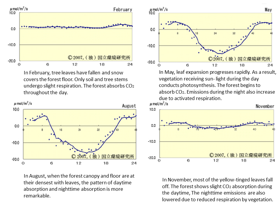
Daily variation of CO2
-
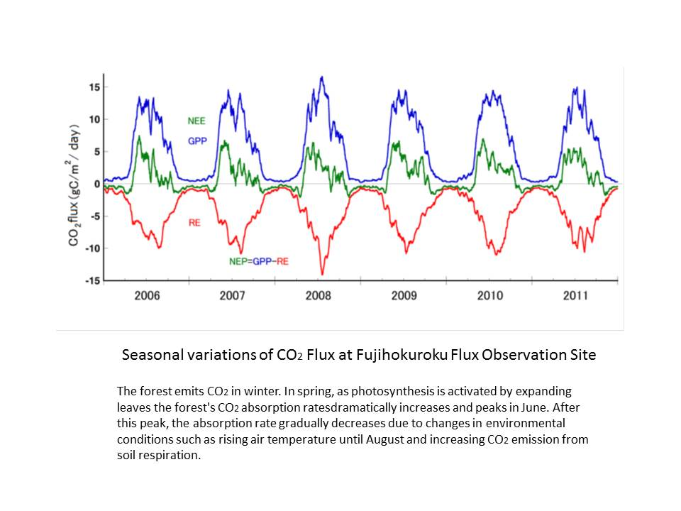
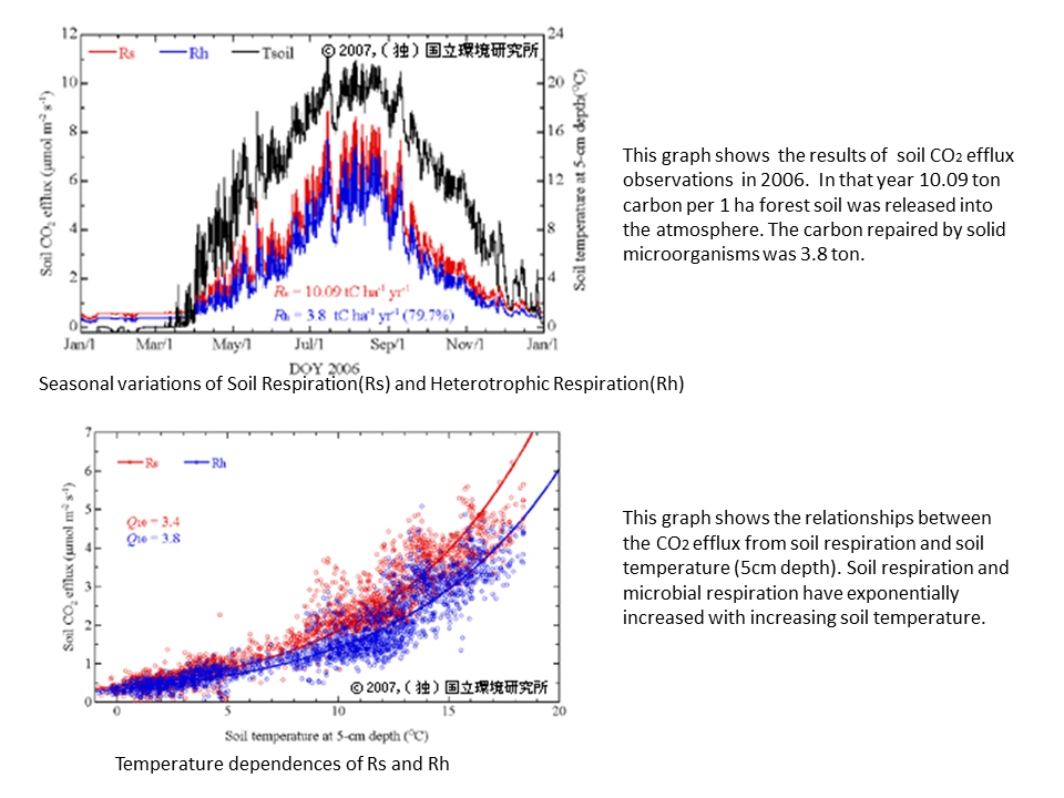
Seasonal variation of CO2
-
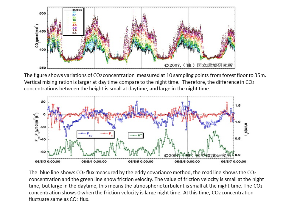
CO2 concentration
-
Variation of CO2
-
Process study
-
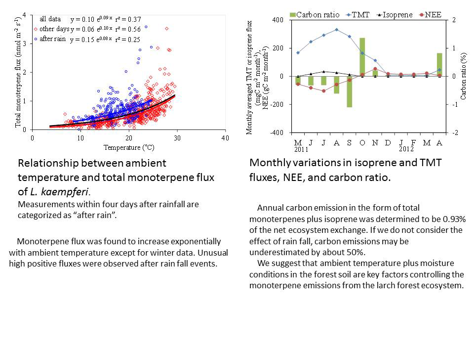
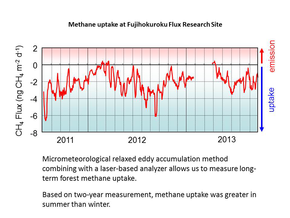
Variation of BVOC